Top 10 Peaks To Hike Around Bozeman
Hikers are as varied as the trails they walk. Some are constantly looking for new challenges, some are content with the same well-known trails. Some want short, level walks, some desire long and steep. There are casual walkers and thru-hikers. There are sunshine hikers and blizzard hikers. A certain type of hiker loves to gain a summit. There are many peaks around the Bozeman area that have trails to the top and are not technical climbs. Here is a list of ten.
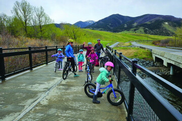
Generally, this list will go from easiest to toughest, but remember that all of these hikes are in the high mountains, so considerations of time and weather are more important than on a hike to the M or a stroll up Sourdough Canyon. Be sure to take along proper gear, food and water. I do not include hiking times along with the distance and elevation, since everyone moves at an individual pace. For example, I find that I tend to hike faster up than down, especially on the steeps. Others run down. Bozeman’s front yard is the Bridgers and its back yard is the Hyalites, so most of the peaks are in those ranges.
Sacajawea Peak
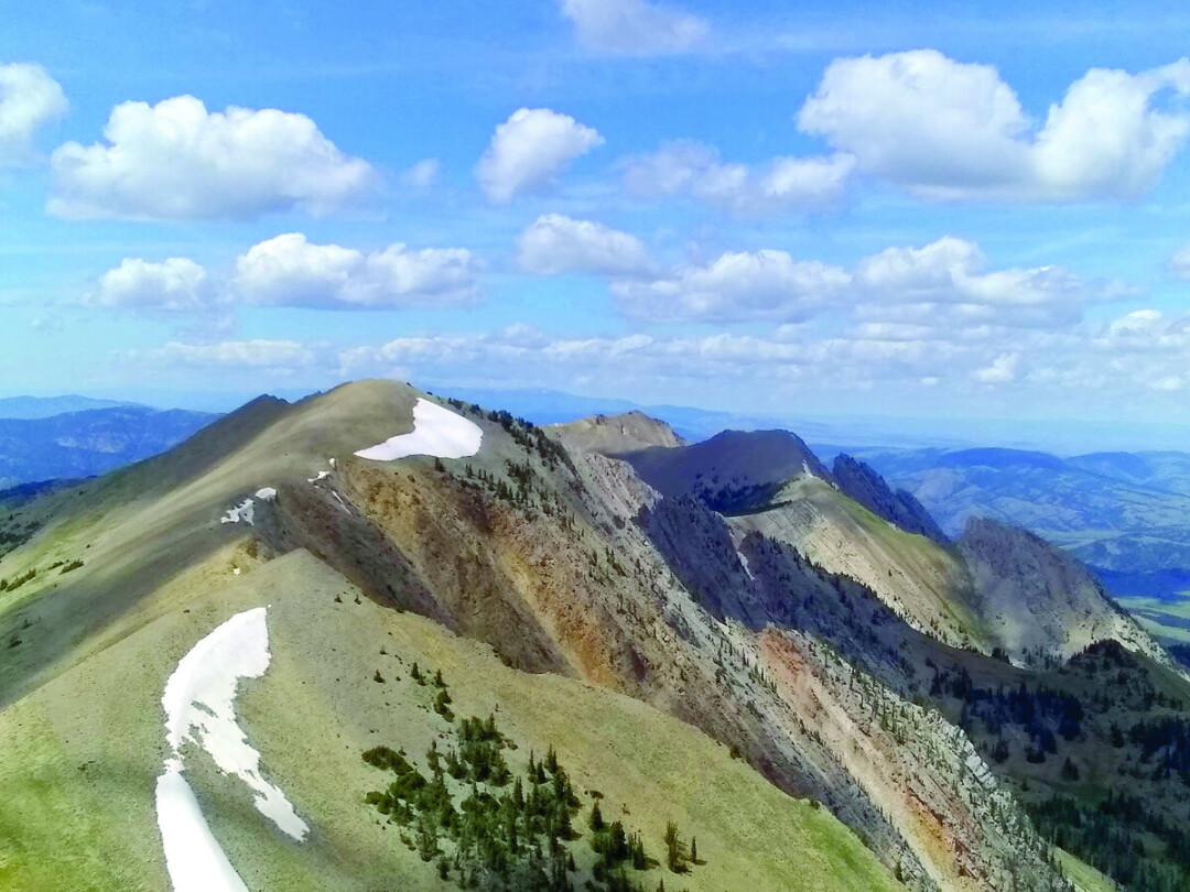
Bridger Range, 9665 ft. Sacajawea is the highest peak in the Briders, and the easiest to climb. The trail begins at Fairy Lake, about a 27-mile drive from Bozeman north through Bridger Canyon. The Fairy Lake road covers the last seven miles. The gate is usually open from June through October. The hike is about five miles round trip and ascends about 2000 ft. In less than a mile, you are in the cirque above timberline, high peaks all around. The alpine tundra setting is stunning. Normally, after reaching the saddle, the last half mile is windy. Even on a summer day it can be chilly. This is the classic Bozeman summit.
Storm Castle
Gallatin Range, 7166 ft.
The top of this little peak looks just like a castle, limestone ramparts reaching toward the sky. The trailhead is on the Storm Castle Creek road, which turns off Gallatin Canyon about 25 miles south of Bozeman. The trail winds up through a fir forest on the south side of the mountain. It’s 2.5 miles to the summit, for a five mile hike. The summit is a lofty, rocky area with views of the Spanish Peaks to the west, the Hyalite Range to the east, and the Gallatin River straight down.
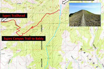
Baldy Mountain
Bridger Range, 8684 ft. Baldy is probably the most popular summit in the Bozeman area. It is the most prominent peak visible from town. Its summit sees people in every month of the year, with the most ascents in the summer. The standard route begins at the M or the Drinking Horse parking lots, about five miles from Bozeman. Hike up the regular M trail, then on up to the south end of the ridge. From there, the trail follows the ridge to the summit. The distance is four miles, for an eight mile round trip. The vertical rise is about 3750 ft. Be prepared to share this trail with many other hikers and runners.
Bridger Peak
Bridger Range, 8880 ft.
The Ridge trail moves on past Baldy to a second, rounded gravelly summit just a couple hundred yards north and a bit higher. The trail winds beneath a broken part of the ridge, then ascends toward and around a higher peak—a much more prominent one. This is Bridger Peak. From three sides it is a climb, but around to the east there is a trail. The summit block resembles a ship, with the prow tapering to a point at the northern end. This peak is about half an hour up from Baldy, a good option if you have more time after the Baldy summit.
Saddle Peak
Bridger Range, 9162 ft.
Saddle Peak is a beautiful twin-peaked mountain a couple of miles north of the Baldy-Bridger group. There are several ways to climb the peak; north from Bridger Peak, south from the Ridgetop at Bridger Bowl, or—probably the best—from Middle Cottonwood trailhead. Drive north on Springhill Road to the Forest Service sign for Cottonwood Canyon. The parking is about 20 miles from Bozeman. The trail heads straight toward the mountain for about a mile, then angles north for the climb to a high pass. The last half-mile of trail to the peak is steep, and leads to the south summit. It is a five-minute walk to the slightly higher north summit. The view is great in all directions.
Mt Ellis
Gallatin Range, 8330 ft.
I should not be the person describing this hike, as I always have trouble with it. There are two main trailheads: New World Gulch up Bear Canyon road, and straight south on Mt Ellis Lane off Bozeman Trail Rd (Kagy). New World is the shorter route, still over eight miles roundtrip. From the end of the Lane, the hike is close to 11 miles. So, even though Mt Ellis looks easily accessible from town, it is a long walk, and either way involves 3000+ feet of elevation. I have always gone up on the New World trail until things opened up, then bushwhacked to the top. Lower Ellis has always beckoned and hiking down from there looks like a quick jaunt to the trail, but those slopes are a maze of old logging roads and tall grass that obscures the route. Better to call it a day after the higher summit and return or ascend the longer trail which is a road for several miles. With either route the view of Bozeman is great, and the expanse of the Bridgers north and the Gallatin Range south even better.
Mt Blackmore
Hyalite Range, 10,154 ft.
The next three peaks on this list are in Hyalite. The reservoir is about 20 miles from Bozeman via South 19th and the Hyalite Canyon road. Depending on which lot you park in, the hike to the top of Blackmore is 11 to 13 miles. There is about 3500 feet of elevation up and down. The trail passes Blackmore Lake after just a mile, then steadily climbs until it begins to switch back up a headwall to a saddle. The trail then loops around to the north for a mile to the summit. There are good camping and resting places along the route. Blackmore is not the highest peak in the Hyalites, but is the most prominent seen from Bozeman because of its position to the west and north of the range.
Hyalite Peak
Hyalite Range, 10,299 ft.
Hyalite Peak is the other classic mountain summit trail hike in the range. Drive another 3.5 miles past the reservoir to the Hyalite Creek trailhead. The trail ascends into the main canyon for 5.5 miles to Hyalite Lake, a shallow pond in a beautiful mountain cirque with great campsites. The summit is two miles past the lake up to a high saddle. The trail leads east to the summit. Hyalite Peak is a huge, Buddha-looking mountain—still not the highest in the range, but a dominating peak. The route is 15 miles round trip with 3650 feet of elevation. Definitely an all-day project, unless a backpacking overnight is planned.
Divide Peak
Hyalite Range, 10,038 ft.
Most of the peaks mentioned so far will have other hikers on just about any summer day, though Ellis, Bridger, and Saddle Peaks could provide a solitary ascent. For the most part, a hiker will be alone on Divide Peak. Use the same parking lot and trail as Hyalite Peak. Where the trail turns east (left) just before Hyalite Lake, another trail heads west. This is the Storm Castle Creek trail, which eventually becomes the SC Creek road, which winds down to Gallatin Canyon. After making the trail turn, I have never seen another hiker, though trail bikes have been known to ride that divide. Two miles up to the saddle, a faint track leads you to the top of Divide Peak. The views encompass the entire Hyalite range, extending south and west to the Madison Range, and east to the Absarokas. This roundtrip hike is a bit longer than Hyalite Peak, perhaps 16 miles, but a little less vertical at around 3400 feet.
Gallatin Peak
Spanish Peaks, 11,015 ft.
This peak is rough and remote. I include it in the list for its beauty, and because, along with Blackmore, it is the highest, most distinctive peak on our southern horizon. Folks who don’t know think it is Lone Mountain. It is not exactly a hike, almost surely an overnight trip. The peak can be approached from the Indian Ridge trail in Gallatin Canyon, or from the North Fork trail at Big Sky. Either climb would go off trail and begin at Thompson Lake from Indian Creek, or Summit Lake from North Fork. The rest is a scramble, if not a climb. The whole trip is 30 miles plus on either route and 4000 feet vertical. Definitely a major undertaking—one to attempt after a lot of experience on these other peaks.
The distances and elevations in this article are from AllTrails and Summitpost. Have fun in the Mountains! This year the snow load is heavy. The Bridgers will open up prior to the other ranges, south-facing routes by mid-June.