Flathead Pass The Northern Bridgers
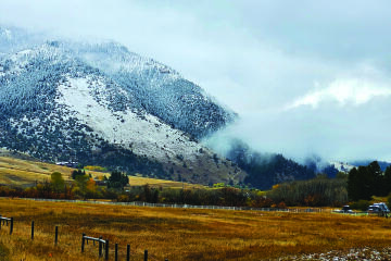
I like to call the Bridger Mountains Bozeman’s front yard. From the parking lot at the ‘M’ to the parking lot at Fairy Lake twenty miles north, there are always vehicles waiting for people to return from their Bridger adventures. But there is another section of the range that is farther away, somewhat remote, even unknown. It is possible to go there and see no one else.
The center of this place is Flathead Pass. To the south of this pass are some of the highest and toughest-to-summit peaks in the entire range. To the north of Flathead there is a ring of mostly tree covered mountains that are rarely ever hiked. How many times have any of us hiked the ‘M’ or skied Bridger? Hundreds? Possibly. I have made just five or six trips to Flathead Pass, though they were all memorable.
On my first try for Flathead Pass, I did not get there. Perhaps I should have gotten the message. In the early 80s I did not know much about the Bridgers, but decided that, if I started from that pass, I would probably end up being able to walk to Bozeman. My wife Ruth drove a friend and I north on a Friday night. The road turned muddy, then impassable. So we got out, and she turned around. We hopped a fence and began walking toward the mountains. Not sure where we ended up that first night—somewhere around Frazier Lake is a guess. In the morning we hiked up, down, and back up and down to Fairy Lake, Sacajawea Peak, and points south. We found the Foothills trail and spent the second night in Truman Gulch, I think. By Sunday, we were weary of the whole endeavor and walked out at Middle Cottonwood. We stopped at a farmhouse and called for a ride. We had covered a lot of ground, but there was no sense of accomplishment, just bumbling fun.
Decades later, my son Scott and I completed that trek. Flathead Pass to the ‘M’. We took two days and two nights. We did gain the ridge a little south of the Pass on Friday night. On Saturday, we traversed all the northern peaks, as well as Sac and Naya Nuki. We camped Saturday night in a not-very-level spot on the Foothills trail a mile or so before Ross Saddle. On Sunday, we hiked the rest of the ridge. The one lasting memory I have of the trip is that it was mid-June, but there was a lot of snow remaining, especially right on top of the ridge. There was no way around some of the drifts; we were in sneakers, maybe had a couple of trekking poles. We had to chop and kick step up vertical snow with drop-offs on either side. By the time we arrived at Baldy, Scott was tired of the whole situation. He ran the rest of the way to get it over with sooner. By the time I wandered into the ‘M’ lot, he was waiting with cold Gatorade.
The Ridge Run covers twenty miles from Fairy Lake to the ‘M’ lot. Ed Anacker, who founded that race, was interested in the northern peaks and ridge. Originally, he wanted the Ridge Run to begin at Flathead Pass. My guess is that was because it would be 26 miles, a marathon distance. He was talked down from that. Thankfully. It is hard enough at 20 miles.
After I retired, I wanted to spend more time in the Bridgers, understand things better. I decided that I needed to drive all the way around the range for perspective, so I went up past Sixteenmile, over to Ringling, south through the Shields Valley, to Livingston and home.
It was a nice drive, but provided no insights. I then decided on a bike ride north from Bozeman on Springhill Road, over Flathead Pass, then south down MT 86 past Bridger Bowl and back to town. I thought the whole ride would be about 70 miles—doable in a long day, but camping and taking two sounded even better.
Since I was spending the night there was no hurry, so I did not get packed up and on the road until 10 a.m. Up N 19th, over to Springhill Road, past Riverside and north. The first ten miles was a breezy hour. The next ten miles, slowed by the end of the pavement at Reese Creek and some gradual steep, took two hours. The last stretch, less than ten miles, took four hours. The turnoff road to the pass, winding past ranches and corrals, cattle and cottonwoods, was enjoyable in some welcome shade. The last few miles to the crest of Flathead Pass were very steep, rocky, and unrideable. I walked and pushed the bike.
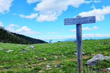
My other ventures to the Pass had been from the east. I knew that Bozeman/Belgrade guys drove their jeeps and pickups from the west in a kind of rite of passage ritual. If they do so, I am impressed. It seemed way too narrow, steep, and rocky for vehicles. I met none. I had to walk and push the bike and 30 pounds of gear in the saddlebags for a couple of miles. The best part was the rushing, falling creek, five feet off the road. I had run out of water and the creek was ice cold. Also good for dipping your hat to cool your head. Near the top, the narrow pass opens wide to large meadows and a broad summit. The road also eases and widens. There was a lot of snow; I tried to avoid it, but the mud was as bad, so I was still pushing. After a few hundred level yards, the road dropped over to the east and into the trees. At least I thought that it was the road. It was under three feet of solid untracked snow. It was early May.
There was no snow on the west side of the mountains. The temperatures had been in the 60s. Maybe the snow would be hard enough to ride on. No. Maybe I could push through to where it had melted out. No. Sometimes I sank into my knees and the bike was way above me and I had to struggle up or sink again. Sometimes the bike dropped in and was way below me and I had to pull it up or sink again myself. I continued this for longer than necessary. The last thing to sink in was a thought. This was not going to get better and I had, at least, to return. I came to a side road that was probably a power company maintenance track. One section was high and dry and grassy, about 30 x 20 feet. It was not far but took ten minutes to push over. I leaned the bike on a tree and sat on a log to think. Something I had not done up to that point.
This effort produced two conclusions. First, I was not going to get off the pass to the east today, tomorrow, or anytime soon. Second, pushing back up to the top of the pass was going to take more energy than I had left. The little spot began to look like camp. I puttered along, setting up my tent and getting the cooking gear out. I walked around, but not far. I had my little area, and when I moved in any direction I sank again into the snow. I paced, fixed supper and ate, paced some more. I was tired but, of course, restless. Retreated to the tent and had a dry, restful night. In the morning, after coffee, I pushed back to the pass. Going down the west side there was no pushing, just a lot of holding the bike back. I got aboard and had a wild ride to the flats. It was downhill all the way to Bozeman. Exactly back the way I had come up, but downhill fun.
I too am fascinated by the Northern Bridgers and when I hike to the saddle, I am just as likely to go that way as up to Sacajawea peak. There are more 9000+ ft peaks there than in the rest of the range. Recently, I watched a Google Earth video that traversed the entire range. On the screen, one of these mountains was named Ed Anacker Peak. I don’t know if this is official. I have been up this peak, but not since I knew of the name. Better go back.
That is one of the unexpected pleasures of writing these essays. Because of lousy powers of observation, forgetfulness, or, in this case, new developments, I have to go back up into the Bridgers. Right now, my list reflects eight more research trips, some an afternoon out, some a couple of days. Bet I could finish them all in a long, fun week. Yet, why rush? And, research usually begets more research, more mountain trips.